Rye Historic Markers
-

Atlantic Cable Station and Sunken Forest
12 Kenphil Ave., Adjacent to Rt. 1A
The receiving station for the first Atlantic cable, laid in 1874, is located on Old Beach Road opposite this location. The remains of the Sunken Forest (remnants of the ice Age) may be seen at low tide. Intermingled with these gnarled stumps is the original Atlantic cable.
-

Awcomin Marsh Restoration Project
The inlet to the 30-acre Awcomin Marsh is located in Rye Harbor. Salt marshes are an important ecosystem providing nesting habitat and food for birds while providing safe and productive places for aquatic species. For 60 years, this marsh was used as a dumping site for spoils from the dredging of Rye Harbor.
-

Brackett Road Burial Grounds
Anthony Brackett and his wife buried here along with other settlers killed in the September 29, 1691, raid. There are no markings on these graves.
-
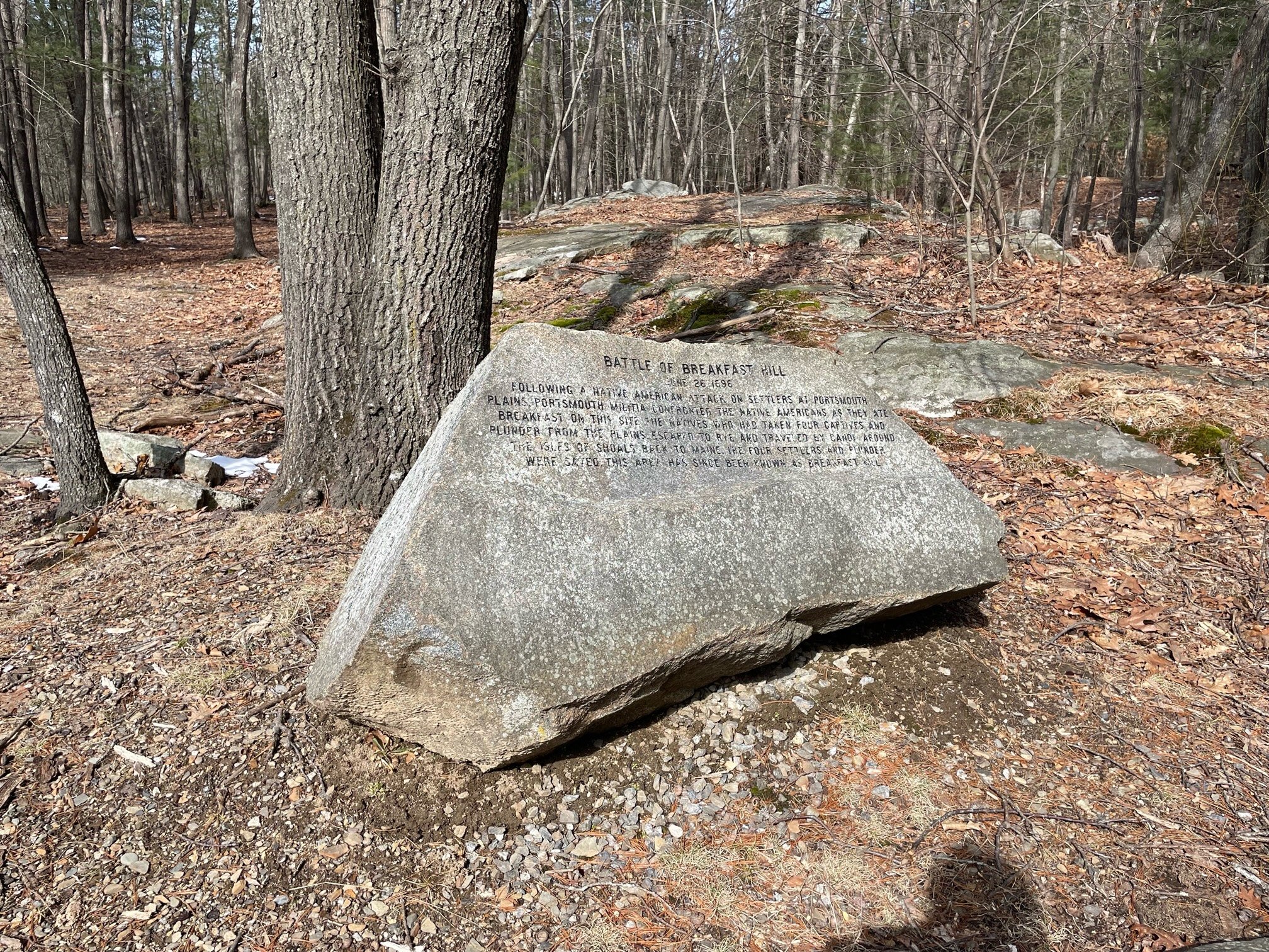
Breakfast Hill Battle Site
601 Breakfast Hill Road, Greenland NH
Following a Native American attack on settlers at Portsmouth plains, Portsmouth militia confronted the Native Americans…
-

Family Farms
Moses Brown married Henrietta Garland in 1876. The year they married, he bought the homestead built by the Marden family at 81 West Road. In 1990 the family named the homestead Brown Lane Farm. Lane is the maiden name of Patricia Brown’s grandmother, Mildred Lane Brown.
-
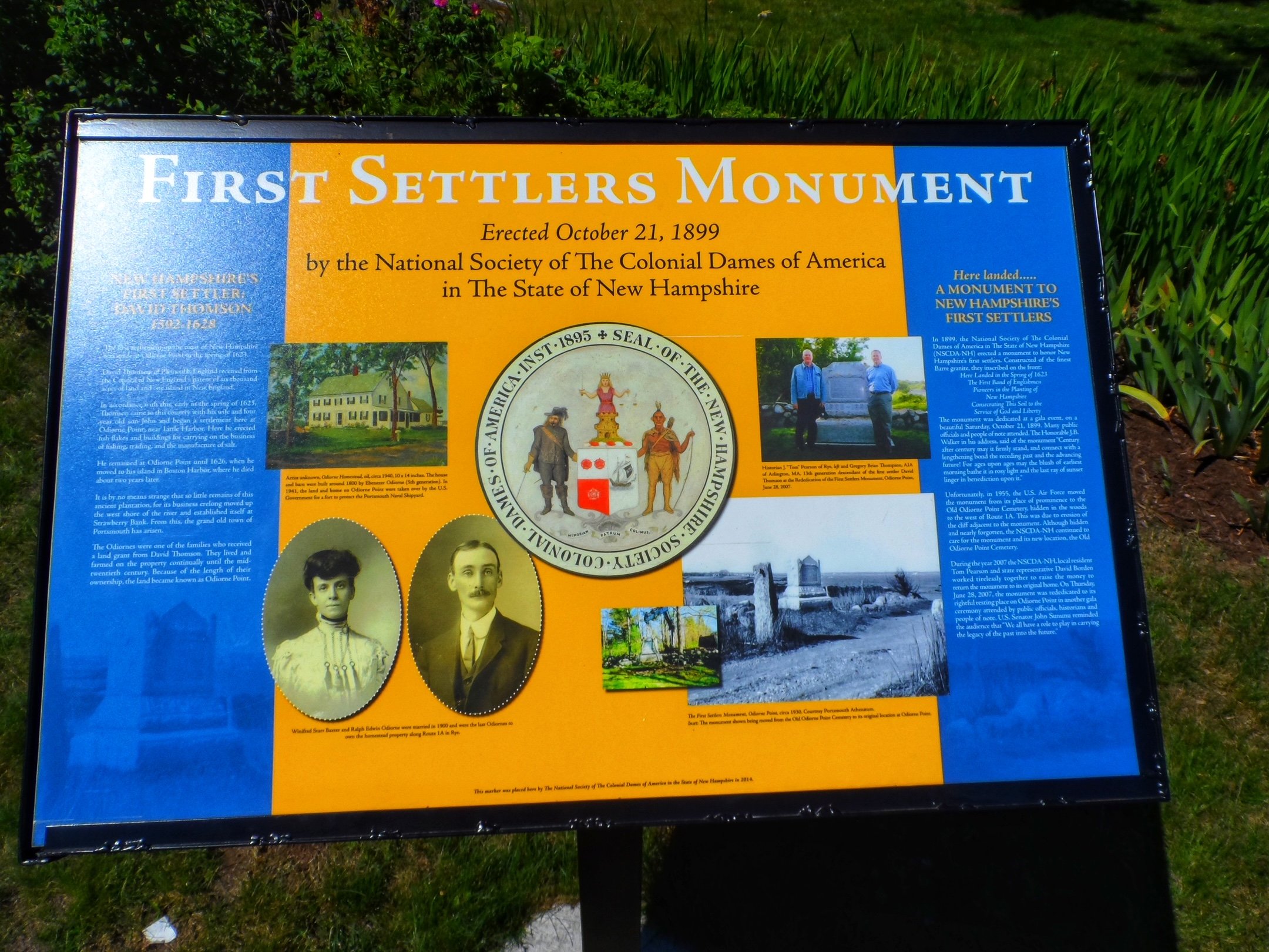
First English Settlers Monument
In 1899, the National Society of The Colonial Dames of America in The State of New Hampshire (NSCDA-NH) erected a monument to honor New Hampshire’s first settlers.
-

Goss Farm
Goss Farm is the oldest known salt marsh farm on the eastern coast of the United States. Nathan Goss purchased the land from the Locke family. His son, General Thomas Goss, built the house and barn in the late 1790’s. In addition to the house and barn, this location had an icehouse, carriage shed, a cottage, corn shed and privy.
-
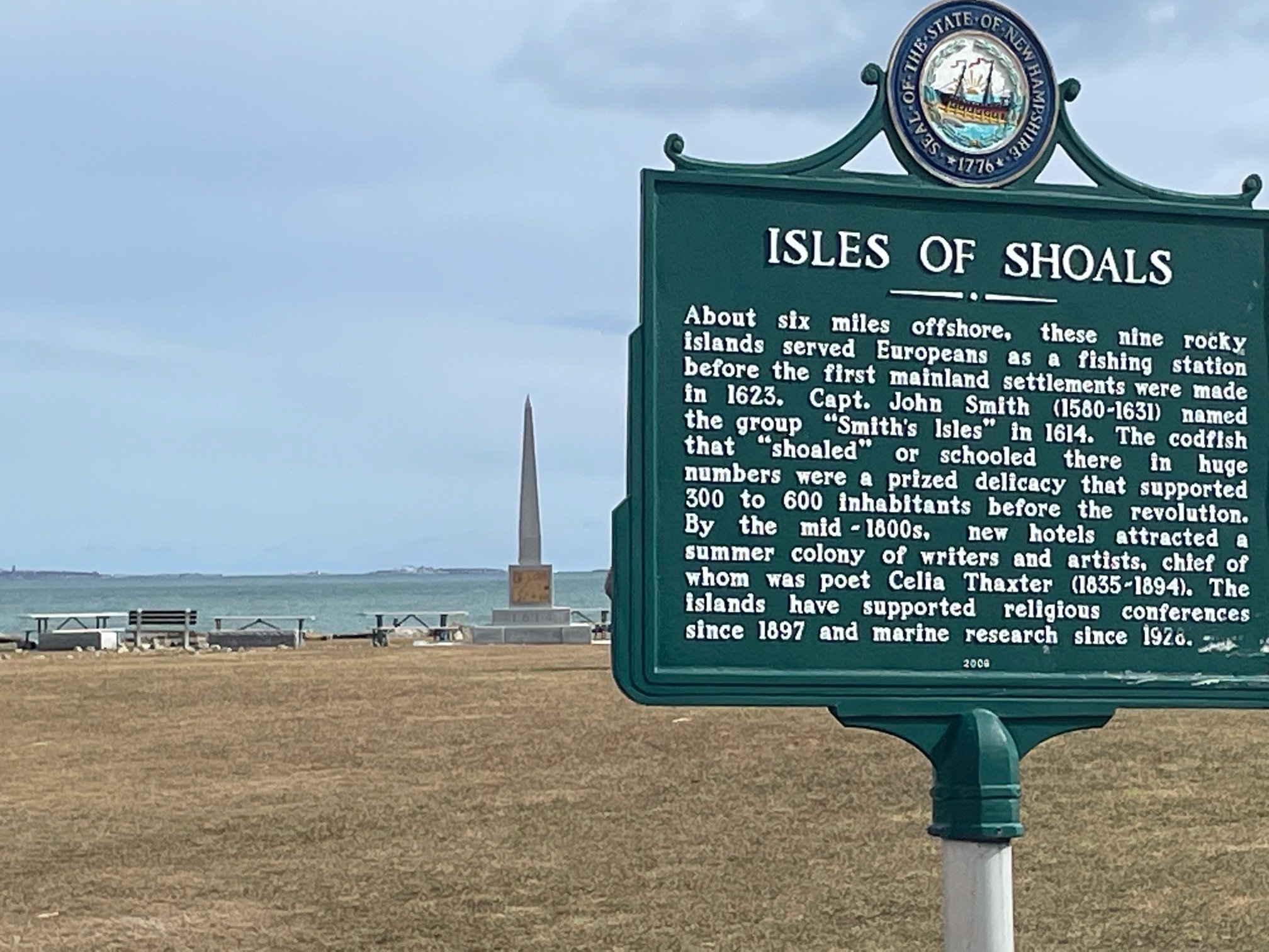
Isles of Shoals
1730 Ocean Blvd., Rye Harbor State Park
About six miles offshore, these nine rocky islands served Europeans as a fishing station before the first mainland settlements were made in 1623.
-

Odiorne’s Point
Here, in the spring of 1623, was established New Hampshire’s first settlement, Pannaway Plantation.
-

Old Odiorne Cemetery
In 1955, the U.S. Aif Force moved the monument to New Hampshire’s First Settlers from its place of prominence to the Old Odiorne Point Cemetary, hiddle in the woods to the west of Route 1A.
-
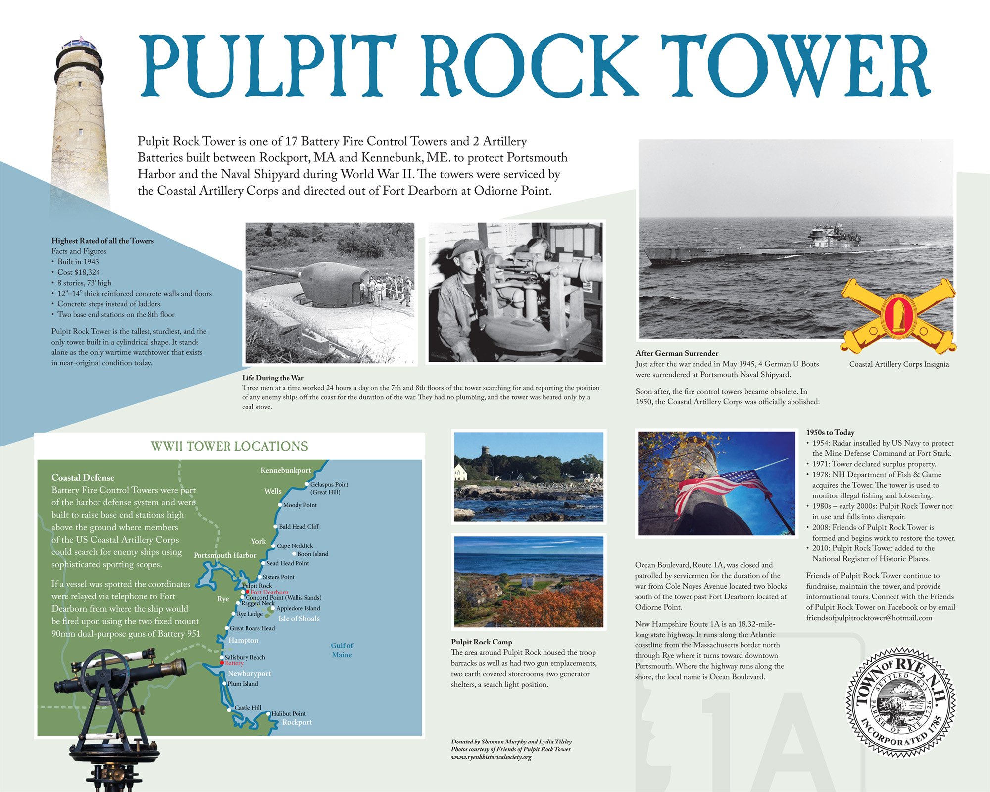
Pulpit Rock Tower
Pulpit Rock Tower is one of 17 Battery Fire Control Towers and 2 Artillery Batteries built between Rockport, MA and Kennebunk, ME. to protect Portsmouth Harbor and the Naval Shipyard during World War II. The towers were serviced by the Coastal Artillery Corps and directed out of Fort Dearborn at Odiorne Point.
-
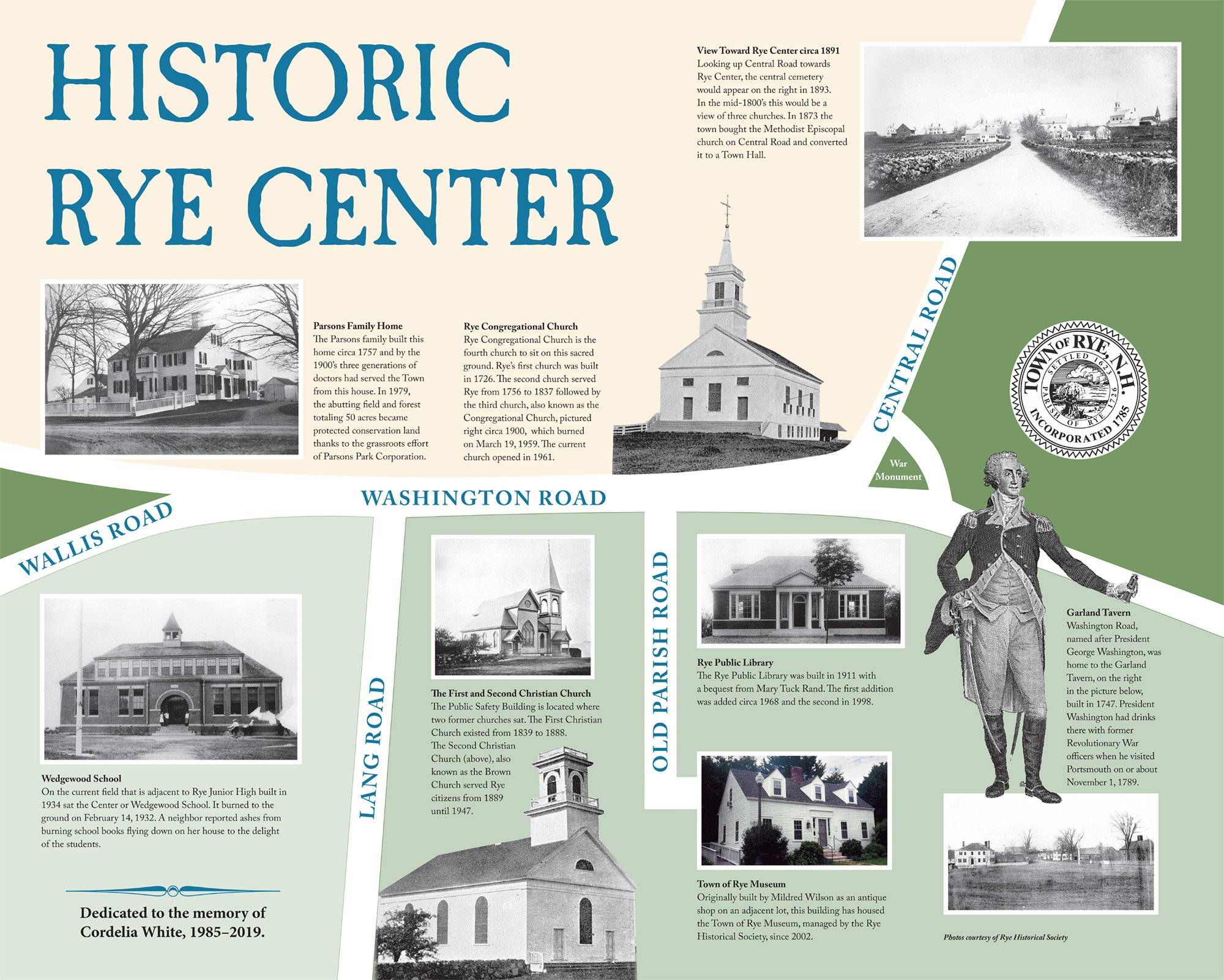
Rye Town Center
Rye Public Library 581 Washington Rd.
Looking up Central Road towards Rye Center, the central cemetery would appear on the right in 1893. In the mid-1800’s this would be a view of three churches. In 1873 the town bought the Methodist Episcopal church on Central Road and converted it to a Town Hall.
-

Rye's Historic Hotels and Resorts
With the coming of the railroad in the early 1840s John Colby Philbrick opened The Atlantic House, Rye’s first hotel in 1846, on Central Road near the ocean. Job Jenness built the Ocean House in 1849 on the end of what is now Cable Road and when it burned, he built the elegant second Ocean House which was destroyed by fire in 1872. Philbrick opened the Farragut Hotel on the ocean in 1864 next to the Atlantic House. In 1869 George Lougee built the four-story Seaview House on Central Road where the Rye Beach precinct building is today. The Sagamore House opened at Odiorne Point in 1869 and burned in 1872.on goes here
-

Trefethen Corner
The first Trefethens to move to this neighborhood were two brothers, Joseph and Nathaniel, sons of Captain William Trefethen. They bought fourteen acres of land in 1813. In 1832 Joseph’s son, Simon, bought the farm at what is now the corner of Clark and Sagamore. In 1864 the Trefethens owned all but a small parcel of land here when Supply F. Trefethen purchased all of James T. Varrell’s property, which is north and east on Sagamore Road.